Selling land or a ranch around Montrose can feel very different from selling a home. You might be wondering how to price acres with irrigation, what documents buyers will ask for, and how long the sale could take. You are not alone. Many sellers here face the same questions, and a little local prep goes a long way.
In this guide, you will learn what drives value in the Montrose land and ranch market, how to set realistic timelines, and which records to pull before you list. You will also get a simple checklist to make buyer due diligence faster and cleaner. Let’s dive in.
What drives price in Montrose
Acreage and location
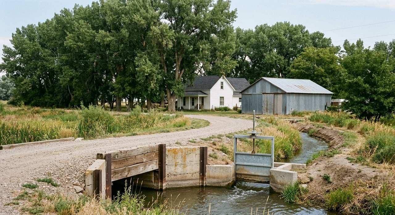
Distance to town, paved access, and proximity to services move the needle. Parcels near Montrose, with highway or paved access, often sell at a higher price per acre and move faster than remote tracts. Local examples show how this plays out in real listings. An irrigated, near‑town property like the Montrose Valley Ranch sold at a premium because of location, water, and improvements, as shown in this Montrose Valley Ranch example.
Price per acre usually declines as parcel size increases. Smaller hobby ranches near town can trade at higher per‑acre prices, while very large ranches tend to price on different buyer needs like grazing, access to public lands, or recreation. Appraisers lean on matched‑pair analysis to quantify these effects, a method outlined in Colorado’s real property valuation manual.
Views and amenity premiums
Mountain, valley, or water views can add value, but the premium varies. There is no universal percent to apply. Appraisers often use paired sales to isolate a view’s impact, as discussed in appraisal literature on view attributes. As a seller, capture wide photos from the best vantage points and identify logical building sites so buyers and appraisers can see the amenity clearly.
Improvements and access
Permitted homes, functioning irrigation systems, barns or shops, good internal roads, and reliable utility connections tend to support stronger pricing. Items that can shrink the buyer pool include unpermitted structures, septic issues, or deferred road work. If you have permit histories or approvals, keep them handy. Montrose County’s planning and development pages outline how permits and entitlements work and are the first place buyers look in their review.
Water: the single largest driver on the valley floor
If your land sits on the Uncompahgre Valley floor, irrigation and transferrable shares often drive the biggest price differences. Buyers and appraisers look for specific share counts and how water is tied to the land. The Uncompahgre Valley Water Users Association history explains how the project and shares work across the valley.
Well rights and surface water are also regulated at the state level. Division 4 (Gunnison Basin) manages permits, augmentation plans, and administration. If you have a well, or plan to develop one, pull the permit file and any construction logs. The state’s Division 4 office page is the hub for local water administration and permitting.
Soils, forage, and grazing
For working operations, soils and carrying capacity matter. Buyers look for irrigated hay yields, pasture performance, and NRCS soils data. Agricultural land is often valued by earning capacity for assessment purposes in Colorado, which is consistent with appraisal practice for ag land. You can see that approach described in the state’s valuation manual.
How long will it take to sell
Do not assume the home market’s speed applies to land. Public aggregators show Montrose County homes trading around the low‑to‑mid $400,000s with moderate days on market, but land often moves more slowly. See the county home context on Realtor.com’s Montrose County overview. Vacant land typically has longer marketing times, especially for larger or remote parcels. Premium irrigated properties near town can move faster when priced well and documented clearly.
Remote or very large tracts may require patience and targeted outreach to the right buyer pool. Listings that border public lands can draw more interest for recreation use, but that does not guarantee a fast sale.
Do this before you list
A clean, local due diligence file helps you price with confidence and reduce buyer friction.
- Title and recorded documents: Pull a recent title report and confirm all recorded easements, covenants, and mineral records. Use Montrose County’s assessor and clerk portals for parcel history and recorded deeds. Start with the Montrose County Assessor.
- Water shares: If UVWUA or ditch water is a selling point, gather current share statements and delivery notes. Include how shares are assigned to acreage.
- Wells and surface water: Run the DWR water‑rights and well‑permit searches for your parcel in Division 4. Note any augmentation plans or administrative calls. Use the state’s Division 4 office resources.
- Zoning and entitlements: Confirm your zoning district, allowed uses, setbacks, and any subdivision rules. Check maps and regulations on Montrose County’s zoning page.
- Hazards and overlays: Download FEMA flood panels, wildfire planning layers, and any county geological hazard maps. Share these with buyers so insurance and financing expectations are clear. See Montrose County’s geological hazards maps.
- Taxes and classification: Verify assessed value, tax history, and agricultural classification status with the Assessor’s office.
Pricing and marketing that work here
- Lead with water and access: Put irrigated acres and exact share counts at the top of your marketing. Add road access type, utility status, and building‑site notes.
- Build comps by water status: Do not mix irrigated and dry‑grazing comps. If your property has transferrable shares, focus on irrigated solds with similar delivery conditions. If dry grazing, look at matching dry‑land sales and adjust for access and size.
- Document improvements: Include permits for homes, wells, and septic, plus irrigation infrastructure and any recent upgrades. Photos of pivots, gated pipe, barns, and power meters help buyers quantify value.
- Show the views and the map: Aerials, topo, and clear boundary visuals make it easier for out‑of‑area buyers to move forward.
- Target the right buyers: Neighboring operators, regional amenity buyers, conservation‑minded owners, and national recreation buyers each care about different features. For example, irrigated near‑town holdings have commanded premiums, while very large remote tracts tend to price lower per acre, as seen in large remote acreage listings.
Your listing file: ready on day one
Create a single digital folder you can send to any qualified buyer. Include:
- Current title report and any surveys or recorded plats.
- Water packet: UVWUA or ditch share statements, water‑decree abstracts, and any augmentation documents with contact info for the ditch company.
- Well permits and any construction logs from the state’s files. Start with the Division 4 office’s water administration page.
- Permit records: building, septic/OWTS, and any signed approvals.
- NRCS soils summary and any pasture or hay‑yield notes.
- High‑quality aerials, topo, and clear parcel ID and legal description.
- Hazard info: FEMA flood data and county geological hazard notes from Montrose County.
What to watch while you are listed
Keep an eye on these signals so you can adjust pricing or terms with real data:
- Recent solds in your micro‑area via MLS and county recorded deeds. Use the Assessor portal to track parcel history.
- Competing acreage inventory and asking prices, especially for properties with similar water status and access.
- Water conditions: Any Division 4 administrative calls or seasonal delivery notes from UVWUA that might affect irrigation timing. See UVWUA history and the state’s Division 4 office.
- County planning updates: Zoning or subdivision changes that could influence buyer expectations. Review zoning maps and regulations.
Setting fair expectations on timing
Small irrigated farms near town can move more quickly if priced with current comps and supported by a complete water packet. Large or remote properties usually take longer. Market aggregators show that land listings often sit longer than homes in Montrose County. For broader context on local housing demand near town, review Realtor.com’s Montrose County overview, then build your land expectation around MLS sold data and your property’s water, access, and improvements.
Bottom line for Montrose sellers
If you remember one thing, make it this: clear, verified water and access details drive faster decisions and better offers. Back that up with accurate zoning, permits, hazards, and recent land comps, and you set the stage for a clean sale. If you want help assembling the right packet, pricing by water status, and reaching the best buyer pool for your acreage, let’s talk.
Ready to sell with a Western Slope specialist who lives this market every day? Schedule a Consultation with Teddy Berger.
FAQs
What affects land price in Montrose the most?
- Irrigation and transferrable water shares, access to town and paved roads, permitted improvements, views, and soils/grazing capacity are the main drivers.
How do I verify my irrigation shares and well rights?
- Confirm UVWUA or ditch shares through association records and run the Division 4 water‑rights and well‑permit searches for your parcel on the state site.
Do irrigated acres sell faster than dry grazing land?
- Often yes, especially near town and when share counts and delivery details are documented, though timeline still depends on pricing and buyer fit.
Where do I find zoning, setbacks, and allowed uses?
- Check Montrose County’s zoning maps and regulations and confirm any site‑specific entitlements with county planning before you list.
What documents should be in my listing packet?
- Title report, recorded easements, UVWUA or ditch share statements, water‑rights abstracts, well permits/logs, permits for structures and septic, soils, maps, and hazards.
Why does land take longer to sell than homes?
- The buyer pool is smaller, financing can be more complex, and due diligence on water, access, and improvements takes time compared to typical residential sales.